AllTrails App Review : Free vs Plus vs Peak Plans Compared
DISCLOSURE: This post may contain affiliate links. If you purchase after clicking one of my links, I may earn a small commission at no extra cost to you. As an Amazon Associate, I earn from qualifying purchases. For more information, see my disclaimer.
If you’ve ever searched for a new hike, chances are you’ve used or at least heard of the AllTrails app. It’s one of the most popular hiking tools worldwide, helping people discover trails, plan routes, and stay on track outdoors. But with so many features split between the free and paid plans, many hikers wonder: Is AllTrails worth it? After years of using it for everything from short hikes to multi-day backpacking trips, I’m breaking down how AllTrails Free, Plus, and Peak compare, and which features are actually worth paying for.
50% Off AllTrails Plus
Planning hikes, downloading maps, getting a little more off-grid without losing your way… this is the upgrade that actually gets used.
AllTrails App Free Version: What You Get
The Base plan is completely free and perfect for casual hikers or anyone exploring new trails, near home or while traveling. You can use AllTrails’ search filters and maps to find trails for hiking, running, mountain biking, off-roading, and more. You can also read reviews, browse photos, and get a feel for the trail before heading out. Navigation helps you stay on track, and you can create lists to save and organize your favorite trails.
UPDATE: AllTrails has brought back the ability to customize existing routes on desktop for free. Desktop planning is fully accessible again!! Simply sign up for free here to start customizing routes today!
Custom Routes on desktop
With the free plan, AllTrails users can personalize existing trails right from the desktop site, whether it’s an official AllTrails-verified route or one shared by another member. You can adjust the path, add waypoints, and make other edits to fit your plans. Once you save your customized route on the website, it automatically syncs to the AllTrails mobile app, ready for navigation on the go. Full step-by-step instructions are included here!
Is the AllTrails App Free Forever?
Yes, it can be. AllTrails is a great way to get a feel for what the app can do. For many hikers, the Base plan gives everything you need to explore nearby trails safely and confidently. But if you’re tackling trails where cell service is spotty or want features like offline maps, Trail Conditions, or Outdoor Lens, upgrading to Plus or Peak may be worth it.
Key Features of the AllTrails Free Plan
- Explore thousands of trails worldwide
- Search filters and map tools for every activity
- Read reviews and view photos
- Navigation to stay on trail
- Save trails and create custom lists
- Customize existing routes on desktop, now free again!
AllTrails Base
- *** Free ***
- Save trails & create lists
- Navigation to stay on route
AllTrails Plus: Who Should Upgrade
AllTrails Plus is a game-changer for safer hiking, and I used to grab my annual membership during one of their 50% off sales.
UPDATE: Trail Conditions is now included in your Plus membership, and will get even better with new detailed ground conditions information rolling out later this month! See additional details below.
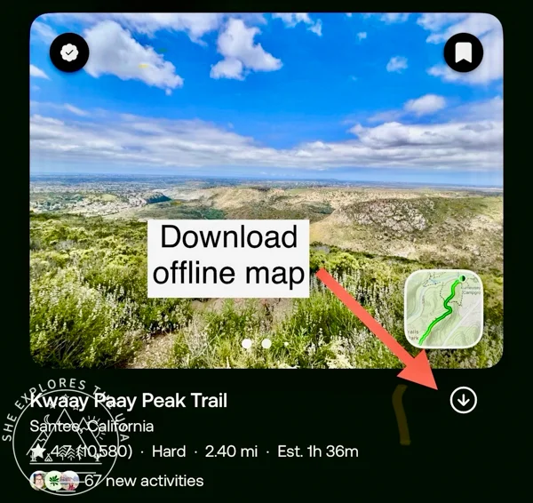
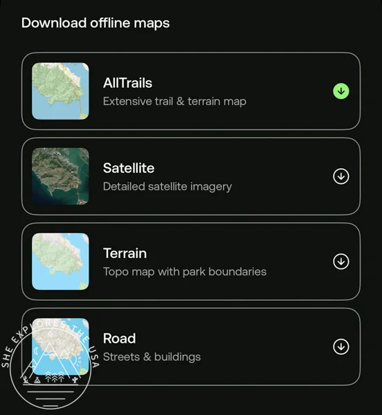
Offline Maps
My absolute favorite feature is offline maps. I cannot stress enough how important they are. They can literally save your life if you lose cell service, and they’re incredibly useful abroad when you want to avoid roaming fees. You can download an offline trail, park, or entire area. And you can choose to download the default AllTrails map, satellite, terrain, and road!
Related to this, another thing I love to do with AllTrails is send the map to my Garmin 67i, and I typically navigate from the Garmin to save on phone battery. You can read more about this in my Garmin 67i review post.
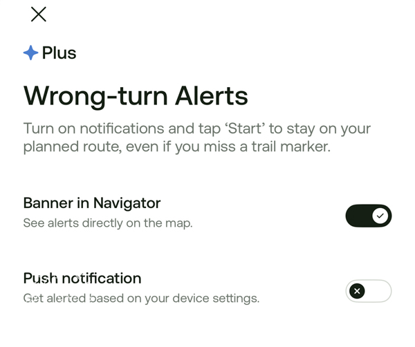
Wrong-Turn Alerts
Another useful safety feature is wrong-turn alerts. If you’re not paying attention, these notifications can help prevent you from getting lost. Just remember to glance at your phone and navigation now and then, and try not to keep it on silent like I always do, so you actually notice the alert when it pops up. 😉
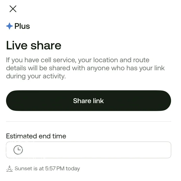
Live Activity Sharing
You can also share live activities with family and friends. Once you start navigating, swipe up to view more options and select “live share” to invite family or friends to track your hike in real time. You can set your estimated return time, and your relatives can even cheer you on along the way with just a tap. It’s a simple feature that adds peace of mind, as long as you have cell service.
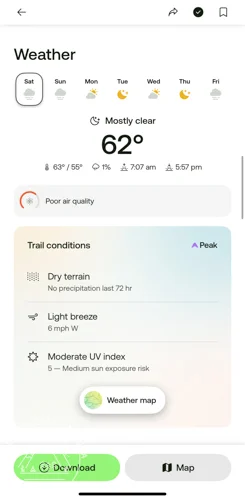
Plan for on-trail conditions
Trail Conditions is super useful for planning your hikes. It shows current and upcoming weather, so you’re never surprised by rain, snow, or muddy sections, and you can even plan to catch the best sunset on the trail.
The feature includes details like temperature, precipitation, snow accumulation, air quality, sun and moon times, and more. All the data comes from trusted third-party sources ( https://www.meteomatics.com and https://www.tomorrow.io/) and input from the global AllTrails community, so you can make smarter decisions about which trail to take and what to pack to stay comfortable. Trail Conditions is dynamic, meaning it updates based on the day, time, and location on the trail, giving you the most accurate snapshot for your adventure.
As my test, I checked the hike I planned for this afternoon. The weather info was spot-on, showing very overcast conditions. It flagged the air quality as poor, though, which seemed off; my iPhone weather app reported it was fine in the same area at the same time. The difference comes down to the scale: AllTrails uses the European Air Quality Index (EAQI), while the iPhone app relies on the USA Air Quality Index (AQI), which can make the same conditions look different.
Convenience & Planning
Beyond safety, Alltrails Plus adds a layer of convenience that makes planning and enjoying your hikes even easier.
Nearby Trails & Trail Lists: Instantly find trails based on your location and download organized trail lists for offline access, super handy when exploring new regions or road-tripping between parks.
Tour Photos & 3D Previews: Get a feel for the terrain and views before you go. The 3D previews and community photos help you know exactly what to expect (and get you hyped for the hike).
Ad-Free Experience: No distractions, just trails. Keep your focus on the outdoors, not interruptions.
AllTrails Plus
- Offline maps & safety alerts
- 3D trail previews & photos
- Ad-free experience & sharing
AllTrails Peak: Is it worth it?
AllTrails Peak is the newest membership tier, released earlier this year. It includes all the benefits of the Base and Plus plans, but adds a lot more flexibility for serious hikers. With Peak, you can create or customize your own routes from your cell phone, and access other advanced tools that help you hike your way, smarter and more prepared.
UPDATE: Following the reallocation of some features to the “Free” and “Plus” membership tiers, the AllTrails Peak experience will remain unchanged. As a bonus, alltrails is extending all current Peak memberships by an additional three months at no extra cost!
Build Your Own Routes
Creating my own routes is hands-down the main reason I upgraded to AllTrails Peak. Often, I see photos on social media of places that look incredible, but there’s no existing trail that hits all the spots I want to visit. That’s when I map out my own route, usually for multi-day backpacking trips in the Sierra.
From Desktop to Mobile
This used to be something you could only do on the desktop version before, but now with Peak, you can build and edit custom routes right from your smartphone. It’s a huge convenience when you’re on the go, as long as you have cell service, of course!
Personally, I find it easier to create a route from scratch on the iPhone app rather than editing an existing one. If you want detailed instructions, AllTrails provides a full guide on how to create and edit custom routes on their support page.
Smart Routing Options
One of the newer features I love is smart routing. Options include:
- Reverse direction
- Double back
- Close loop
- Make shorter
- Reduce elevation gain
- Take the scenic route
These can be especially helpful if you’re new to an area or planning a multi-day adventure. For example, when I tested a 21.5-mile, 4,925 ft elevation gain route I’d created last year in the Sierra:
- Clicking “reduce elevation gain” initially erased the route completely (maybe the AI doesn’t work with older routes created on AllTrails+).
- “Make it shorter” and “take the scenic route” did the same thing.
To be fair, the AI was right: not doing the hike at all was the best way to reduce elevation gain and to make the hike shorter!😉
After recreating the route from scratch on my iPhone, the AI behaved more sensibly:
- “Reduce elevation gain” displayed a message saying it couldn’t reduce it; at least it didn’t erase the route.
- “Take the scenic route” added scenic stops, lengthening the route by about 2 miles and adding 300 ft of elevation gain.
Making Smarter Decisions on the Trail
Once your route is built, the reverse direction is awesome. For loops, especially, it quickly lets you compare which direction is easier on elevation, helping you choose which direction is best to protect your knees or lungs!
My Verdict
Overall, being able to create routes from the iPhone app, combined with the smart routing options, adds real value and makes upgrading to AllTrails Peak worth it for anyone who likes to plan their hikes precisely.
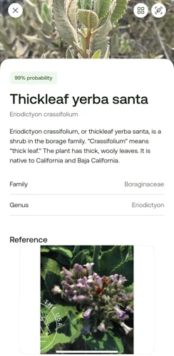
Identify plants and more with Outdoor Lens
Not gonna lie, I was a little surprised to see this listed as a paid-for feature, since my iPhone has offered plant ID for free for years. But when I tested AllTrails’ Outdoor Lens and compared it side-by-side with the iPhone version, I noticed one interesting difference: AllTrails actually includes toxicity information.
That’s definitely useful if you’re curious (or cautious) about what’s growing around you. Still, keep in mind that the results come from AI, so they’re not always 100% accurate. It’s best to double-check with a trusted field guide or reliable source before making any assumptions, especially about what’s safe to touch or eat.
AllTrails also automatically creates a logbook of your discoveries, recording details like GPS coordinates, elevation, and the date and time you found each plant or insect. It’s a fun way to keep track of your outdoor finds over time.
One thing to note: Outdoor Lens requires cell service to deliver the identification results. If you try to ID a plant or insect while out of range, the app will save your attempt and give you the results once you’re back in service.


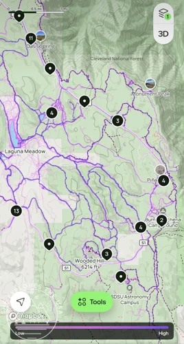
Community Heatmaps
With Community Heatmaps, you can see where the most popular trails are, and where to go if you want to avoid the crowds. It’s a great idea in theory, especially for planning weekend hikes or discovering hidden gems.
However, in practice, trail popularity can vary a lot depending on the time of day, season, and even weather. The heatmap data reflects trail activity from the past 12 months and is updated monthly, but you can’t currently filter by specific time periods.
In my experience, all the trails in the area I tested looked equally “busy,” and the purple shading didn’t differ enough to clearly show quieter vs. more popular spots (though maybe that’s just my eyesight!). Hopefully, future updates will include time-based filters, which would make this feature a lot more useful for real trip planning.
AllTrails Peak
- Custom routes & planning tools
- Plant & nature identification
- Community heatmaps & trail insights
AllTrails Plus vs Peak: Which Upgrade Is Worth It?
Base (Free) Plan
Perfect for casual hikers who stick to local trails or areas with reliable cell service. You’ll get access to trail maps, reviews, photos, and navigation; everything you need to explore nearby without spending a dime.
Plus Plan
Best for anyone who hikes regularly or ventures into areas with spotty signal. The offline maps, wrong-turn alerts, and live tracking features bring real peace of mind for you and your loved ones. It’s a smart safety investment that can make all the difference on the trail.
Peak Plan
Ideal for adventure lovers who like to plan in detail. From 3D terrain previews and custom routes to international trail data and on-trail condition reports, this tier is built for serious planners and explorers who want the full AllTrails experience.
Other Features You Might Love
Ultimate National Park Planner
If, like me, you’re slowly checking off all the national parks, in the U.S. and beyond, AllTrails makes it easy with guides for over 200 national parks. These guides include curated trail collections and insider tips from the AllTrails team for parks across the United States, Australia, Canada, England, Ireland, New Zealand, Scotland, and Wales.
For example, if you’re exploring Yosemite National Park, you can filter for hikes with epic views to plan the most scenic routes and make the most of your trip. Each park guide highlights the top sights, multiple curated trail lists, and popular routes, plus practical info like seasonal photos, park hours, passes and fees, and accessibility details. It’s everything you need to plan your visit in one spot.
Garmin connection
I can send AllTrails maps to Garmin for navigation, which saves my phone battery, and I can also record my activity using Garmin, and it updates AllTrails at the end upon syncing.
Tag a friend
When you end your hike recording, AllTrails asks: “Did anyone join you?”
It’s a fun and thoughtful feature that lets you tag your hiking buddies, even if their phone died or their tracking glitched halfway through.
Tagging friends not only gives them credit for the hike, but it also creates a shared memory in your AllTrails history. It’s a small touch that makes your adventures feel more connected and collaborative.
Give the Gift of Adventure
An AllTrails subscription makes a simple, thoughtful gift for any outdoor lover. Personalize a message, send it by email or print it to hand-deliver, and let your friends or family explore new trails, plan hikes, and enjoy the outdoors. It’s the perfect gift for hikers for birthdays, holidays, or any occasion.
AllTrails Shop: Gear Worth Checking Out
AllTrails doesn’t just help us find trails; they also make sure we’re ready for them. Their shop has a growing selection of outdoor apparel and accessories, plus limited-edition collabs with trusted adventure brands that make great gifts (for yourself or your favorite hiker 😉).
AllTrails × Stio Collection
This cozy, fall-ready line includes technical hoodies, joggers, half-zips, and fleece layers that work just as well in town as on the trail. Shop the full AllTrails × Stio collection here.


AllTrails × Black Diamond Collection
For the more technical side of adventure, this collab brings lightweight shell jackets, trekking poles, headlamps, and packs built for serious weather and rugged terrain. Shop the AllTrails × Black Diamond gear here.


Pros & Cons of the Alltrails App
I find that AllTrails is a great asset for anyone who enjoys hiking and backpacking. It’s convenient, easy to use, and packed with features that make it easier (and safer) to explore new places.
The main downside I’ve noticed is that some of the trails listed aren’t actually real trails. I mentioned this in my Cucamonga Peak Hiking report. That’s because users can submit routes to AllTrails, so occasionally you’ll come across something that doesn’t exist or isn’t well-marked in real life. As long as you do your research, you’ll be fine.
Pros
- Convenient and easy to use
- Massive database of trails worldwide
- Excellent safety tools (like offline maps & wrong-turn alerts)
- Syncs with Garmin, Apple Watch, and more
- Ability to create and customize your own routes (Peak)
- National park guides for over 200 parks worldwide
- Plant and insect ID with logbook (Peak)
- Recent User reviews provide insights on trail conditions, including water sources, snow conditions, and other practical info
Cons
- Some user-added trails may be inaccurate or nonexistent
- Community heatmaps can be hard to interpret and aren’t time-specific
- AI route tools sometimes behave unexpectedly on older routes
- No monthly subscription option
FAQs About AllTrails
What is the AllTrails app?
AllTrails is a hiking and outdoor navigation app that helps you discover, plan, and track trails all over the world. You can search for hikes by difficulty, distance, elevation gain, or user ratings, and even download maps for offline use.
How does the AllTrails app work?
The app uses GPS to help you navigate and stay on trail, showing your real-time location on downloadable maps. You can also read trail reviews, track your stats, and log completed hikes. Premium membership tiers unlock extra features like offline maps, weather overlays, and custom route building on smartphones.
What are the different AllTrails memberships?
AllTrails offers three tiers:
- Base (Free): Access to trail maps, reviews, and tracking, and customize existing routes on desktop.
- Plus: Adds offline maps, wrong-turn alerts, weather and trail conditions, and 3D map viewing.
- Peak: Includes everything from Plus, plus advanced tools like smart route editing, and Outdoor Lens for plant and insect identification.
Is the AllTrails app really free?
Yes, the AllTrails Base plan is completely free and includes access to thousands of trails, navigation, and community reviews. However, most hikers find that upgrading to AllTrails Plus is well worth it for offline maps, weather & trail conditions, safety alerts, and peace of mind on the trail. If you like building your own routes or planning complex backpacking trips, AllTrails Peak is the best choice, but everyone should at least have Plus.
How do I contact AllTrails customer service?
AllTrails doesn’t list a public phone number for live support. The best way to reach them is through their support page.
What’s the difference between AllTrails Plus and AllTrails Peak?
AllTrails Peak includes everything from the Plus plan and adds new features like AI-powered route creation and editing, and Outdoor Lens for plant and insect ID.
Is AllTrails worth it?
If you hike regularly or travel to new trails often, yes! The offline maps alone make the Plus subscription worthwhile. Peak adds more convenience, safety, and customization that can really enhance your time outdoors.
Final Thoughts on the AllTrails App Review
I’ve been using AllTrails for several years now, and it’s become one of my most-used hiking tools. The Free version is great for casual hikes near home, while Plus adds peace of mind with offline maps, safety alerts, and live tracking; features I consider essential for backcountry adventures. Peak offers extra planning tools and route customization, which are fun and useful if you like to plan your hikes in detail, but for most hikers, Plus covers the essentials.
I do wish there were a monthly plan option, as some months I only need Plus, and a few months I want Peak. That aside, AllTrails is a reliable, intuitive, and feature-rich companion for hikers at any level, whether you’re exploring nearby trails or planning a big adventure.
Post originally published on November 2, 2025, and last updated on April 4, 2026.